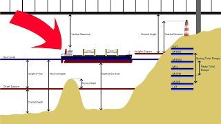
Chartwork Tutorial: Datums, Depths & Heights
Комментарии:

Sir you are the best.... i passed my OOW orals because of your Colregs vedios it helped me alot thankyou god bless.
Ответить
Clearance heights (Bridges, power lines etc) are now measured from HAT on UK Admiralty charts, for added safety.
Ответить
Sir. If the MHWS for a fixing place is always same?and where can I find it?
Ответить
how can i join the community
Ответить
Great explaination I watched before one hour to exam 😀😀👍💥
Ответить
As always, your instruction is both super clear, concise and a joy to watch and learn though I must say I find the narration a bit fast to catch at one instant. Had to rewind and listen again.But that's only me, a second-language English speaker. Thanks once again for sharing.
Ответить
Please make a video about current diamonds. Please please please 🙏🙏🙏
Ответить
Suddenly boats and ships running into bridges makes way more sense!
Ответить
Waiting for u r contents💌
Ответить
Very well explained. Excellent.
I would like a video about other types of datums, eg WGS 84. And maybe one about different chart projections (mercator, great circle..) Thank you

Great refresher, spot on!
Ответить
Outstanding content as always 💯❤️
Ответить
![Street Walk in Olongapo City Zambales Philippines From Sin City to Model City [4K] Street Walk in Olongapo City Zambales Philippines From Sin City to Model City [4K]](https://ruvideo.cc/img/upload/c3RpdERBRVUxT0U.jpg)

![Walking at Night in Downtown Olongapo Zambales Philippines [4K] Walking at Night in Downtown Olongapo Zambales Philippines [4K]](https://ruvideo.cc/img/upload/TWlRQnFKUkVSaHg.jpg)


