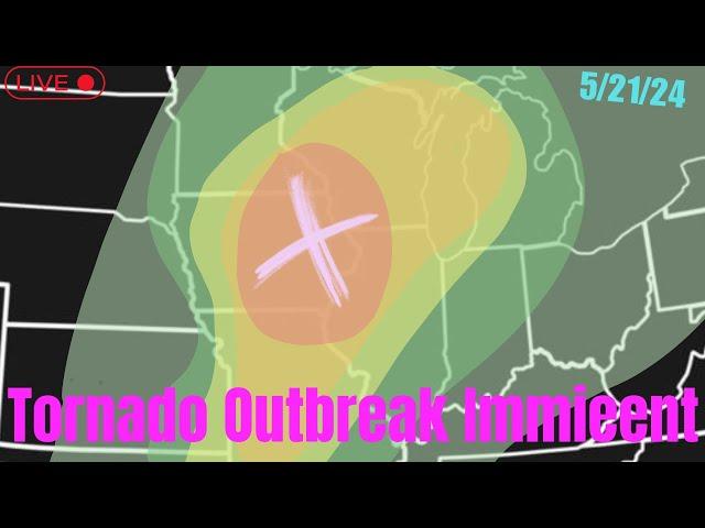
The Strongest Tornado EVER, As It happened.
SUBSCRIBE FOR MORE LIVE UPDATES!
.THERE IS A HIGH RISK OF SEVERE THUNDERSTORMS FROM CENTRAL AND
NORTHERN OKLAHOMA INTO SOUTH-CENTRAL KANSAS...
...SUMMARY...
A regional outbreak of severe weather with multiple intense (EF3+),
long-tracked tornadoes, as well as very large hail and severe
thunderstorm gusts, is expected over parts of the south-central
Plains from this afternoon through evening.
...20Z Update...
Recent surface analysis places a low over far southeast MT, with an
occluded front arcing southeastward to the triple point near far
southwest SD/far north-central NE Panhandle. A cold front extends
southward from this triple point across far eastern CO and then back
south-southwestward across eastern NM. A dry line also extends
southeastward from this triple point into south-central NE before
arcing back more southward/south-southwestward across western KS,
the eastern TX/OK Panhandles, and into TX Trans-Pecos.
Thunderstorms developed quickly along the dryline from south-central
NE into north-central KS, as well as ahead of the occluded front in
southwest SD. General expectation outlined in the previous
discussion (appended below) remains, with thunderstorm coverage and
intensity expected to increase as the shortwave trough continue to
progress northeastward into the central High Plains. Eventual
organization into more of an eastward-progressing convective line is
anticipated, with the resulting line moving across southern NE and
northern KS. Primary threat with this line will be severe wind gusts
up to 80 mph. Some line-embedded QLCS tornadoes are also possible,
particularly as the line enters southeast NE and northeast KS later
this evening amid a strengthening low-level jet. STP values from 3
to 5 appear likely across southeast KS ahead of the line this
evening.
Farther south (from south-central/southeast KS into most of OK), the
airmass continues to destabilize ahead of the dryline. Upper 60s
dewpoints are now approaching the KS/OK border, with low 70s
dewpoints now moving into central OK. Visible satellite imagery
continues to show relatively limited vertical development across OK,
with some stable undulations noted as well, both of which are
indicative of a capped airmass. This is verified by the 18Z OUN
sounding, which showed that notable capping remains in place. This
capping is a few degrees higher than estimated by the 12Z guidance.
Even so, deepening cumulus has been noted along the dryline across
the eastern TX/OK Panhandle, and recent initiation has occurred in
southwest KS, both of which suggest initiation of additional storms
farther south is probable around 20 to 22Z.
Overall scenario for a potentially volatile afternoon and evening
remains for south-central KS into western and central OK. An
isolated storm could also develop in far northwest TX. Supercells
capable of all severe hazards are still expected, with the
environment becoming more favorable with time and eastern extent.
All guidance continues to indicate STP values around 10 are likely
in the 00 to 06Z timeframe across western and central OK. Giant hail
up to 4" in diameter, severe gusts up to 80 mph, and long-track,
intense tornadoes are all possible. Particularly Dangerous Situation
(PDS) Tornado Watch #189 was recently issued to cover this threat.
..Mosier.. 05/06/2024
.PREV DISCUSSION... /ISSUED 1102 AM CDT Mon May 06 2024/
...NE/KS/OK to north TX...
Water-vapor imagery late this morning shows a potent mid- to
upper-level trough/low over the central Rockies with a speed max
moving through the base of the trough and into the southern and
central High Plains. This negatively tilted mid level trough will
continue northeast to near the Black Hills by this evening while its
southern portion overspreads the KS/OK corridor. The 12z Amarillo,
TX raob showed the leading edge of stronger 700-600 mb southwesterly
flow nosing eastward into the High Plains. A cyclone near the NE
Panhandle this morning will deepen as it moves north-northeast to
the SD/ND border early Tuesday morning. An associated Pacific front
will push east into the High Plains and overtake the northern
portion of the dryline across parts of the central High Plains this
afternoon into this evening. Farther south, a dryline will mix east
into western OK by late this afternoon with a broad moist/unstable
warm sector across the southern Great Plains and becoming
increasingly pinched in spatial width farther north into the
north-central Great Plains. An attendant warm front will advance
northward from OK into the lower MO Valley by early evening and
later into the mid MS Valley.
Комментарии:
The Strongest Tornado EVER, As It happened.
Crazycars81
Reacting to WHY I HATE GEARS IN BRAWL STARS!
Coach Cory - Brawl Stars
Destiny 2: The Final Shape - Excision
Augy Productions
La Folia-Emilie Autumn
LovelyDespair1
Look What I Made With Foam Pool Noodle and Wicker Rope!
SULTANIN OYUNCAK ATÖLYESİ
Elvis Presley - Girl Happy (original pitch!!)
ELVIS - SoundAndArt


![D-Devils - The 6th Gate (Dance With The Devil) [Official] D-Devils - The 6th Gate (Dance With The Devil) [Official]](https://ruvideo.cc/img/upload/a1RWdk1Vcjk4cjE.jpg)


![최강 검사 남주가 송사리 부대에 들어가면 벌어지는 일 [애니리뷰/쿠키있음] 최강 검사 남주가 송사리 부대에 들어가면 벌어지는 일 [애니리뷰/쿠키있음]](https://ruvideo.cc/img/upload/c21uRkNyTmF2amQ.jpg)


