MAP OF ALABAMA
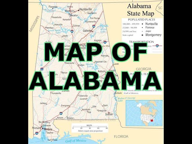
hello my friends. this is a map of beautiful Alabama. Alabama is the thirtieth-largest state in the United States with 52,419 square miles of total area: 3.2% of the area is water, making Alabama 23rd in the amount of surface water, also giving it the second-largest inland waterway system in the United States. About three-fifths of the land area is part of the Gulf Coastal Plain, a gentle plain with a general descent towards the Mississippi River and the Gulf of Mexico. The North Alabama region is mostly mountainous, with the Tennessee River cutting a large valley and creating numerous creeks, streams, rivers, mountains, and lakes.
Alabama is bordered by the states of Tennessee to the north, Georgia to the east, Florida to the south, and Mississippi to the west. Alabama has coastline at the Gulf of Mexico, in the extreme southern edge of the state. The state ranges in elevation from sea level at Mobile Bay to more than 2,000 feet in the northeast, to Mount Cheaha at 2,413 ft. hey. excuse me. please comment if you love Alabama. continuing.
Alabama's land consists of 22 million acres of forest or 67% of the state's total land area. Suburban Baldwin County, along the Gulf Coast, is the largest county in the state in both land area and water area.
The Natural Bridge Rock in Winston County is the longest natural bridge east of the Rockies.
Areas in Alabama administered by the National Park Service include Horseshoe Bend National Military Park near Alexander City; Little River Canyon National Preserve near Fort Payne; Russell Cave National Monument in Bridgeport; Tuskegee Airmen National Historic Site in Tuskegee; and Tuskegee Institute National Historic Site near Tuskegee. Additionally, Alabama has four National Forests: Conecuh, Talladega, Tuskegee, and William B. Bankhead. Alabama also contains the Natchez Trace Parkway, the Selma To Montgomery National Historic Trail, and the Trail of Tears National Historic Trail.
Notable natural wonders include: the "Natural Bridge" rock, the longest natural bridge east of the Rockies, located just south of Haleyville; Cathedral Caverns in Marshall County, named for its cathedral-like appearance, features one of the largest cave entrances and stalagmites in the world; Ecor Rouge in Fairhope, the highest coastline point between Maine and Mexico; DeSoto Caverns in Childersburg, the first officially recorded cave in the United States; Noccalula Falls in Gadsden features a 90-foot waterfall; Dismals Canyon near Phil Campbell, home to two waterfalls, six natural bridges and allegedly served as a hideout for legendary outlaw Jesse James; Stephens Gap Cave in Jackson County boasts a 143-foot pit, two waterfalls and is one of the most photographed wild cave scenes in America; Little River Canyon near Fort Payne, one of the nation's longest mountaintop rivers; Rickwood Caverns near Warrior features an underground pool, blind cave fish and limestone formations; and the Walls of Jericho canyon on the Alabama-Tennessee state line.
the Cliffs at the rim of the Wetumpka meteorite craterare nice too.
A 5-mile -wide meteorite impact crater is located in Elmore County, just north of Montgomery. This is the Wetumpka crater, the site of "Alabama's greatest natural disaster". A 1,000-foot - wide meteorite hit the area. The hills just east of downtown Wetumpka showcase the eroded remains of the impact crater that was blasted into the bedrock, with the area labeled the Wetumpka crater or astrobleme ("star-wound") because of the concentric rings of fractures and zones of shattered rock that can be found beneath the surface. In 2002, Christian Koeberl with the Institute of Geochemistry University of Vienna published evidence and established the site as the 157th recognized impact crater on Earth. thats all for now. thanks for listening. please subscribe for the best maps and for the love of alabama. goodbye. #mapschool #maps #mapas #alabama https://youtu.be/s1X0c_CRG5k
Тэги:
#map_of_alabama #alabama #alabama_map #map #mapa #mapa_alabama #carte #阿拉巴马州地图 #خريطة_ألاباما #carte_de_l'Alabama #mapa_de_alabama #map_of_alabama_coast #map_of_alabama_lakes #map_of_alabama_cities #map_of_alabama_counties #map_of_alabama_airport #map_of_alabama_and_georgia #map_of_alabama_state_parks #map_of_alabama_rivers #map_of_alabama_gulf_coast #map_of_alabama_and_florida_beaches #road_map_of_alabamaКомментарии:
MAP OF ALABAMA
maps
Amelie - Short film genre swap
Gule Korkmaz
GET READY with me - Part 01
Thileni. On Air
Top 5 WINNING Products To Sell Now (Shopify Dropshipping)
Jeremy Ray Holst
초보 토지투자자의 큰 생각의 틀 잡기
부동산 토지투자 랜드홍
Top 10 worst own goals #gt
Maximin💛🩵_edits


![[뮤지션새끼] 순간의 끝 - 연우 (Made By 연우) [뮤지션새끼] 순간의 끝 - 연우 (Made By 연우)](https://ruvideo.cc/img/upload/QVAwbUVPdV9oUlM.jpg)


